Tidal Schuylkill River
Welcome to Your Riverfront!
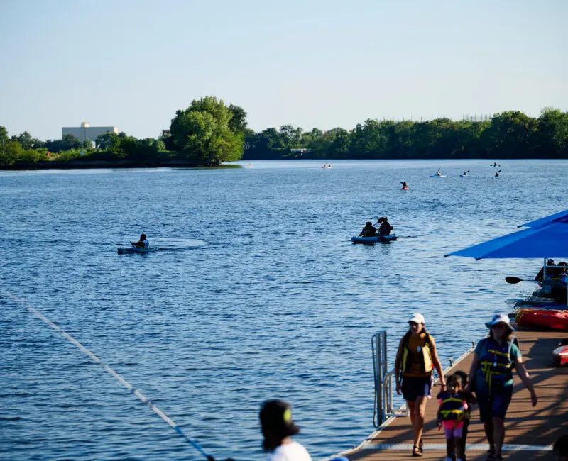
Bartram’s Garden is located on the banks of the Tidal Schuylkill River, which runs along the eastern edge of the park. With a half-mile of riverfront, ecologically significant tidal wetlands, and an accessible public dock, this is a place where everyone can connect with the river.

The river is for everyone to enjoy!
Join us at weekly free fishing and boating, borrow free fishing rods & tackle from the Welcome Center, launch your own boat from our public dock, cast your fishing line from our piers and overlooks, contact us to schedule group boating or fishing for Southwest Philadelphia organizations, or join our Boathouse Volunteer crew.
Thousands of people each year enjoy boating, fishing, and other river access programs along this quiet stretch of river, in part because the health of the Tidal Schuylkill has improved significantly over the past decades, which has also improved environmental conditions for plants and animals.
In 2025, we celebrated 10 years of free public fishing and boating on the Tidal Schuylkill River.
Upcoming Events


How We Use River Data
Periodic impacts from pollution and climate change negatively influence water quality, impacting the health of the aquatic ecosystem and affecting public river access.
Bartram’s Garden uses river data to help inform the safety of our public river programs like fishing and boating. Programs are canceled when data indicates that the river conditions may not be safe for public access or sometimes for other reasons like weather or staffing.
Why test the water?
The Tidal Schuylkill River is a public waterway that everyone can enjoy, just like a city park, and our river recreation programs are designed to be as safe as possible for as many people as possible. We use data about river health to help inform when and how programs take place. Since 2018, Bartram’s Garden has collected water quality data to support safe public access to the river for activities like boating and fishing.
Historically, government agencies and researchers have not collected much water quality data from this section of the river. As we accumulate data, our understanding of the health of the Tidal Schuylkill River will continue to grow.
How does this data guide safety decisions?
Bartram’s Garden uses recreational water quality criteria (RWQC) recommendations from the U.S. Environmental Protection Agency (EPA) to guide our water quality standards for recreation in which participants are likely to have physical contact with the water. We use these standards because most of our boats are kayaks, in which people are likely to get fairly wet through splashing while paddling or from water collecting in the base of the boat. To learn more about what to expect while boating, click here.
We focus our sampling efforts on E. coli bacteria levels, which is an indicator of fecal contamination that the EPA and PA Department of Environmental Protection (PA DEP) use for their water quality criteria. We also collect information about many other variables in the river, like depth, temperature, cloudiness (turbidity), and more. Click here for the most recent data.
Rainfall can increase the risk of unsafe levels of pathogens in the water, so Bartram’s Garden cancels public boating programs if Philadelphia has received more than 0.25 inches of rain within 24 hours before the program’s start time, even if it it’s not currently raining at the time of the program–that means that even on a beautiful sunny Saturday, we sometimes have to cancel boating owing to rain on Friday.
In addition, our fishing programs are all catch-and-release, in keeping with the recommendations from the PA Department of Environmental Protection to limit consumption of fish from the Tidal Schuylkill River. Click here to learn more about the issues impacting the Tidal Schuylkill.
How does water quality testing work?
Our river program staff collect and analyze water samples at least weekly during our public program season to test for bacterial and nutrient levels. In partnership with Stroud Water Research Center, we also host an EnviroDIY Mayfly sensor station in the river near our dock that measures additional physical and chemical properties of the water and records these readings every five minutes. The data below represents the most recent sensor station data and the most recent water sample tests.
The data below is available to help explain why contact with the river is safer on some days than others. We use this data to inform our public river programming. Hear more about the process from recent Denkyem River Guardians youth interns:
About the Tidal Schuylkill River
Archaeological evidence shows that humans have lived along this river seasonally for more than 5,000 years, due to the reliable source of food. While it is not clear if the indigenous Lenni Lenape had a single name for this river, some believe it was called Ganshowahanna, meaning “falling or roaring waters,” or Tool-pay Hanna, meaning “Turtle River.” Schuylkill, the name given by Dutch colonists, means “hidden river.” Click here to learn more about the history of this area.
The section of the Schuylkill River that borders Bartram’s Garden is tidal, so the direction of the flow reverses about every 6 hours, and the water level fluctuates by 5 to 7 feet twice a day, creating wetland and mudflats along the banks. The Tidal Schuylkill flows into the Delaware River to the south, and the health of these waterways is vitally important.
As part of the Delaware River Watershed, the Tidal Schuylkill sustains life for hundreds of species, including humans. There are over 200 species of birds that visit or live along this section of the river, such as red-winged blackbirds, barn swallows, double-crested cormorants and great blue herons. There are over 100 diverse species of plants such as mulberry tree, spatterdock, and foxtail grass. In the river, we find aquatic animals such as red-bellied turtles and pickerel frogs and over 50 species of fish, including channel catfish, white perch, common carp, bluegill, and American eel.
This biodiversity makes the Tidal Schuylkill River a vital and dynamic part of Philadelphia’s natural landscape. The return of some species that are intolerant of high levels of pollution demonstrates that the river’s water quality has improved in recent years.
More about the Tidal Schuylkill River
The Schuylkill River flows for 135 miles from Pottsville, Pennsylvania, to Philadelphia, where it joins the Delaware River. Like any river, the Schuylkill is part of a much wider system known as a watershed. The Schuylkill River watershed spans an area of nearly 2,000 square miles and supplies drinking water to over 1.5 million people across southeastern Pennsylvania. In fact, the City of Philadelphia sources all of its drinking water from the Schuylkill and Delaware Rivers, and the entire Delaware River watershed––which includes the Schuylkill River watershed––provides drinking water to 15 million people.

Still at Risk: Issues Impacting the Health of the River
Although the Schuylkill River watershed was heavily developed, industrialized, and polluted in past centuries, the river has become significantly cleaner and healthier in recent decades thanks to federal legislation regulating pollutant discharge into waterways as well as the migration of some of that heavily polluting industrial development to other countries.
However, despite the many creatures––including humans––who rely on the increased health of the river, billions of gallons of pollutants still impact the river’s health each year and limit the ways in which we can access it. The area’s industrial legacy continues to have an impact, and both old and new pollutants are still routed into the river via stormwater runoff and overflows of the city sewer system.
How does the sewer system impact the river?
Combined sewer systems are pipes that carry both sewage and stormwater runoff, and they were standard parts of city infrastructure until the mid-20th century, when separate systems for sewage and stormwater became the norm. Normally, both the sewage and stormwater from combined sewers go to a treatment plant to be cleaned. However, when it rains a lot, there is too much water for the pipes to handle.
When a high volume of stormwater runoff rushes into the sewer, combined sewers may overflow, releasing an untreated mix of sewage and stormwater into local waterways, including the Tidal Schuylkill. These events are called combined sewer overflows (also shortened to CSOs). As a result, our rivers tend to be more polluted after heavy rains, and recreational use of the river may be more restricted after rain because of potentially unsafe bacterial levels in the water. The recurring pollution from combined sewer overflows can also have broader ecological impacts, especially for aquatic plants and animals.
Like many historic cities, over 60% of Philadelphia is served by a combined sewer system that was originally built beginning in the 1700s when the city’s population was much smaller and so produced a smaller volume of sewage. Population growth, combined with more paved surfaces due to urbanization, have increased the volume and frequency of CSOs. More frequent and intense rainfalls due to climate change continue to exacerbate the problem.
The city has 40 combined sewer overflow locations along the Tidal Schuylkill River and 54 on the Delaware River, as well, plus an additional 31 along the Franklin and Pennypack Creeks, both of which flow into the Delaware River. Philadelphia is not the only urban area that pollutes the Schuylkill and Delaware Rivers: the Schuylkill River Watershed alone spans 11 counties. Camden also has CSOs along the banks of the Delaware River in New Jersey. All the water and pollutants in the Schuylkill River Watershed naturally enter the Schuylkill River and funnel towards Philadelphia.
What about pollution?
The Schuylkill River, like many waterways in the United States, also still holds traces of legacy pollution resulting from decades of heavy industry. While a series of laws in the 20th century, such as the 1905 Purity of Water Act and the 1972 Clean Water Act, did much to make our rivers and waterways cleaner, PCBs, mercury, heavy metals, and other remnants of pollution are still present in the sediment at the bottom of the river.

E. coli
E. coli (pronounced “ee koh-lie”) is a tiny germ that lives inside animals, including people. Most of the time, it’s harmless and lives in our guts, helping with digestion. But sometimes, certain types of E. coli can make us sick if we eat or drink something that’s contaminated.
Pathogens
Pathogens are tiny organisms like bacteria, viruses, or fungi that can make people sick. They can enter our bodies through things we eat, drink, breathe, or touch. Pathogens cause diseases by multiplying inside our bodies and disrupting how our cells work. E. coli is an example of a waterborne pathogen.
Watershed
A watershed is an area of land where all the water drains into the same river, lake, or ocean. Imagine a big bowl with sloping sides — when it rains or snows, the water runs down those slopes and collects in the lowest part of the bowl. That lowest part is where all the water from that area ends up. Everything that happens in a watershed, like pollution or changes to the land, can affect the water quality and all the plants, animals, and people that live there.
PCBs
PCBs, or polychlorinated biphenyls, are chemicals that were used in things like electrical equipment, such as transformers and capacitors, because they could handle heat well and didn’t easily catch fire. However, they were found to be harmful to the environment and to people’s health. PCBs can get into rivers, lakes, and soil, where they stay for a long time and can build up in animals and humans. Because of their harmful effects, their use has been restricted or banned in many places around the world to protect the environment and our health.
Temperature: How warm or cold is the river?
Different species have different temperature needs, but in general 0 to 30 degrees Celsius (32 to 86 degrees Fahrenheit) is a healthy range for aquatic life. Water temperatures are impacted by a variety of factors, including time of day, seasonal changes, weather conditions, water flow, and tidal cycles. Climate change can cause water temperatures to rise, which can result in deoxygenation, as warmer water contains lower levels of dissolved oxygen.
Dissolved Oxygen: How much oxygen is in the water?
Low levels of oxygen in the water can impair animals’ respiration and weaken their health, and over time this issue can lead to reduced levels of biodiversity and changes in how the ecosystem functions. Oxygen levels are typically higher during the day and lower at night. They can also vary seasonally, as the water temperature changes. A dissolved oxygen concentration above 5 milligrams per liter (mg/L) is considered a healthy level for a river like the Schuylkill, while lower levels are linked to ecosystem stress.
Turbidity: How cloudy is the water?
High levels of turbidity can reduce the amount of light that enters the water, which impacts the ability of fish and other organisms to find food and to navigate and also affects photosynthesis. Generally, turbidity below 50 NTU (Nephelometric Turbidity Units) is considered a healthy range, although a formal water quality criteria is not defined in Pennsylvania, and levels can spike during or after storms.
Depth: How deep is the water?
Generally, the depth of the river’s edge at Bartram’s Garden ranges from 2–10 feet, and in the center the river can be more than 30 feet deep. The river’s depth changes by 5 to 7 feet–the height of a person!–between high and low tide. During high tide, water from the ocean flows upstream, or north, into the river and increases the depth. During low tide, the water flows back out to the ocean, towards the south, causing the river’s depth to decrease.
Conductivity: How salty is the water?
Conductivity measures how well water can conduct electricity, which is influenced by the concentrations of dissolved ions like salts and minerals. Pollutants can also contain ions or dissolved substances that conduct electricity, so sudden large changes in conductivity —especially increases—may mean that some type of runoff or pollution has entered the river. 150 – 500 uS/cm (microsiemens per centimeter) is a healthy range, and levels can spike during and after snowstorms when city agencies and residents use salt to treat the roadways and sidewalks for ice. Rainfall, warm temperatures, and high tides can also cause increases in conductivity.
Other Pollutants
Owing to contamination from legacy pollutants like PCBs, the DEP provides recommendations limiting consumption of fish from the Tidal Schuylkill River. As of October 2023, the general recommendations from the PA DEP are as follows:
- Limit consumption of any fish caught in any state waterway to one meal per week.
- For white perch, channel catfish, flathead catfish, and striped bass greater than 28” in length caught in either the Tidal Schuylkill River or the Delaware River, limit consumption to one meal per month.
- Limit consumption of carp to six meals per year.
- Avoid consumption of American eel.
Click here to see the DEP’s current recommendations on fish consumption from Pennsylvania waterways.
Most Recent Water Quality Data
Past data suggest that while bacterial levels vary significantly based on many factors, unsafe river conditions are likely when there is more than 0.25 inches of rain within a 24-hour period, due to combined sewer overflows.

E. coli data collected at the Bartram’s Garden dock provides a snapshot of the bacterial concentrations in the water on the days and times the samples were collected. After heavy rain, E. coli levels in rivers typically surge due to runoff carrying contaminants from various sources, including urban areas, agricultural lands, and wastewater discharges. CSOs further elevate bacterial concentrations in the water after rain.
According to the EPA, the recommended values for primary contact recreation like kayaking are as follows:
- the 30-day geometric mean value should be no more than 126 cfu/100 mL and
- the 30-day statistical threshold value should be no more than 410 cfu/100 mL.
Want to Know More about River Conditions?
Our live water quality sensors also collect data on other aspects of the river to give us more information about current conditions.
As of Summer 2026, the sensors are currently offline for maintenance.

Temperature:
How warm or cold is the river?
The temperature of a body of water influences what type of organisms live there and also affects other water quality parameters.
Dissolved Oxygen:
How much oxygen is in the water?
Aquatic life relies on dissolved oxygen to survive.
Turbidity:
How cloudy is the water?
Turbidity is caused by suspended particles in the water such as sediment or organic matter, which reduce the ability of light to pass through water, resulting in cloudiness.
Depth:
How deep is the water?
In some areas, the Tidal Schuylkill can be over 30 feet deep!
Conductivity:
How salty is the water?
Even freshwaters, like the Tidal Schuylkill River, have salt and other minerals in them!
Other Pollutants:
How many fish are safe to eat?
The PA Department of Environmental Protection recommends limiting consumption of fish from the Tidal Schuylkill.
River Advocacy & Getting Involved: What Happens with This Data?
In addition to learning from our data to inform our own safety practices at Bartram’s Garden, we share data with regional agencies to advocate for improved protection of river health and water quality. For example, in 2020, we sent a letter to two agencies that implement water quality standards for the Tidal Schuylkill, asking them to expand their own testing and improve consistency between the agencies. You can learn more from our partners at River Network.
Since then, the PA Department of Environmental Protection has conducted their first assessment of the Tidal Schuylkill for water contact recreation. We are also a member of the Riverways Coalition, partnering with other organizations along the Schuylkill, Delaware, and local creeks to expand community water quality monitoring efforts and compare data. In 2024, Bartram’s Garden and other Riverways organizations reviewed and submitted comments on the PA DEP’s Draft 2024 Integrated Water Quality Monitoring and Assessment Report, concerning the assessment and listing of the tidal portion of the Schuylkill River.
Get Involved
For more information about how to get involved in river access at Bartram’s Garden, contact riverprogram@bartramsgarden.org.
Citations
- Bird List, https://ebird.org/hotspot/L715915/bird-list, Aug 2024.
- Commonwealth of Pennsylvania Public Health Advisory 2022 Fish Consumption, Fish Consumption Advisory, Pennsylvania Fishing Summary/Boating Handbook, www.fishandboat.com, May 2024.
- E.Coli (Escherichia coli) Factsheet on Water Quality Parameters, www.epa.gov, May 2024.
- PA DEP water quality criteria (25 Pa. Code Chapter 93. Water Quality Standards (pacodeandbulletin.gov))
- Fishing the Tidal Schuylkill, Schuylkill Banks, schuylkillbanks.org, April 2024
- How Philadelphia’s water Pollution Problems Shaped the City, Science History Institute Museum & Library, Distillations Podcast, Sciencehistory.org, April 2024.
- Polychlorinated Biphenyls (PCBs) Update: Impact on Fish Advisories, EPA Fact Sheet, epa.gov, May 2024.
- Public Notification of Combined Sewer Overflows, CSOcast, water.phila.gov/maps/csocast/, May 2024
- Schuylkill River at Bartram’s Garden (PUSR2S), Monitor My Watershed, Monitormywatershed.org, April 2024.
- COMMONWEALTH OF PENNSYLVANIA (state.pa.us)
Credit
- Interface Studio
- Waterborne Environmental, Inc.
- Mandy Katz
This page made possible by support from the John S. and James L. Knight Foundation.